![](/images/other/stat-length.png)
![Randonnée Marche Le Gua - Le Pieu depuis Les Petits Amieux - Photo](https://media.geolcdn.com/t/1900/400/bc0f1a32-2a26-4597-a0e3-8997a2b8a6b8.jpg&format=pjpeg&maxdim=2)
Le Pieu depuis Les Petits Amieux
patjobou
Utilisateur
![Longueur](/images/other/stat-length.png)
![Altitude max](https://static1.geolcdn.com/siteimages/upload/files/1508320355ic_sort_altitude_max_24dp.png)
![Dénivelé positif](https://static1.geolcdn.com/siteimages/upload/files/1508320355ic_sort_den_pos_24dp.png)
![Km-Effort](/images/other/stat-length.png)
![Altitude min](https://static1.geolcdn.com/siteimages/upload/files/1508320355ic_sort_altitude_min_24dp.png)
![Dénivelé négatif](https://static1.geolcdn.com/siteimages/upload/files/1508320355ic_sort_den_neg_24dp.png)
![Boucle](https://static1.geolcdn.com/siteimages/upload/files/16400158638029165_repeat_loop_refresh_sync_direction_icon.png)
![Marche](https://static1.geolcdn.com/sitytour/trail-icons/101.png)
4h54
Difficulté : Moyen
![Scannez ce code QR pour ouvrir la randonnée dans l'application SityTrail](https://capi.geolives.com/qq0zvz2zws4bq2lad0pu/sitytour/trails/2992444/qr.png?size=200)
Application GPS de randonnée GRATUITE
À propos
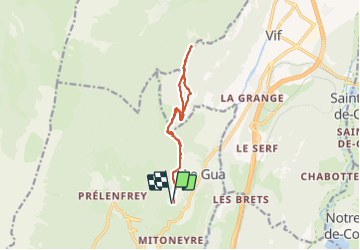
Randonnée Marche de 11,8 km à découvrir à Auvergne-Rhône-Alpes, Isère, Le Gua. Cette randonnée est proposée par patjobou.
Description
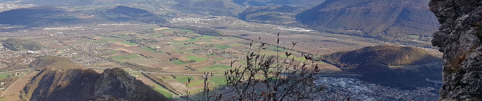
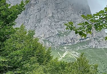
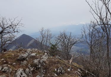
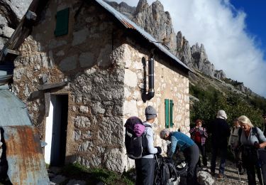
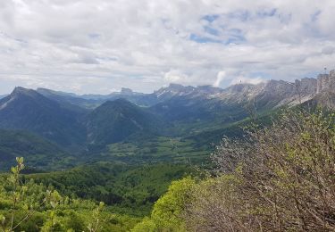
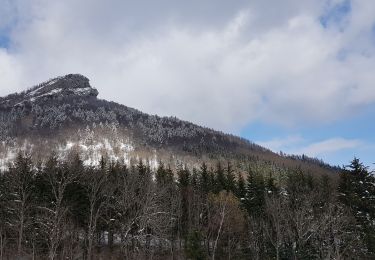
Bel itinéraire, belles vues sur Grenoble, la Chartreuse, la Mathésine, et la vallée de La Gresse. Le parking aux Petits Amieux permet un départ progressif, avant d'attaquer la montée soutenue, après l'Echaillon, et sur la crête; (toujours sur un bon sentier). Au sommet, on ne manquera pas de laisser un message sur le cahier prévu à cet effet, au pied de la croix. Descente par Les Perrins, moins glissante que l'itinéraire de montée, par cette journée fraîche d'automne. Ce sentier 'oublié' est encore visible, et sa pente régulière est parfaite pour la descente.
Un itinéraire agréable, à proximité de Grenoble.
Photo 8, vers le sud, dans le sens de la descente: le départ de la descente vers 'Les Perrins'. Au début pas encourageante, puis rapidement, on tombe sur un ancien sentier, très agréable; attention à ne pas le perdre à proximité des Perrins.
Localisation
Commentaires
Randonnées à proximité
![Randonnée Marche Château-Bernard - la soldanelle - Photo](https://media.geolcdn.com/t/375/260/75f3f6c9-7fa9-4e53-8263-c310156b3409.jpg&format=jpg&maxdim=2)
![Marche Marche](https://static1.geolcdn.com/sitytour/trail-icons/101.png)
Marche
![](/images/other/stat-length.png)
![](https://static1.geolcdn.com/siteimages/upload/files/16400158638029165_repeat_loop_refresh_sync_direction_icon.png)
![Randonnée Marche Vif - la ferme oriol en circuit - Photo](https://media.geolcdn.com/t/375/260/40456475-f1df-45a6-819a-93e9ddb16412.jpg&format=jpg&maxdim=2)
![Marche Marche](https://static1.geolcdn.com/sitytour/trail-icons/101.png)
Marche
![](/images/other/stat-length.png)
![](https://static1.geolcdn.com/siteimages/upload/files/16400158638029165_repeat_loop_refresh_sync_direction_icon.png)
![Randonnée Marche Château-Bernard - tête des chaudières et rocher de la Balme - Photo](https://media.geolcdn.com/t/375/260/0195d12b-3165-4d3f-81a6-2df422d450fa.jpg&format=jpg&maxdim=2)
![Marche Marche](https://static1.geolcdn.com/sitytour/trail-icons/101.png)
Marche
![](/images/other/stat-length.png)
![](https://static1.geolcdn.com/siteimages/upload/files/16400158638029165_repeat_loop_refresh_sync_direction_icon.png)
![Randonnée Marche Château-Bernard - sous pas Balme de Arzelier - Photo](https://media.geolcdn.com/t/375/260/ad496dd6-d014-4fff-96cc-8f3a271c17a6.jpg&format=jpg&maxdim=2)
![Marche Marche](https://static1.geolcdn.com/sitytour/trail-icons/101.png)
Marche
![](/images/other/stat-length.png)
![](https://static1.geolcdn.com/siteimages/upload/files/16400158638029165_repeat_loop_refresh_sync_direction_icon.png)
![Randonnée Marche Le Gua - Un tour de L'Eperrimont par le sommet ! - Photo](https://media.geolcdn.com/t/375/260/86c123e6-6997-4f93-970a-703604abf85f.jpg&format=jpg&maxdim=2)
![Marche Marche](https://static1.geolcdn.com/sitytour/trail-icons/101.png)
Marche
![](/images/other/stat-length.png)
![](https://static1.geolcdn.com/siteimages/upload/files/16400158638029165_repeat_loop_refresh_sync_direction_icon.png)
![Randonnée Marche Le Gua - Tour des arêtes du Gerbier - Photo](https://media.geolcdn.com/t/375/260/e28f2edb-9b96-4c03-9a1e-b9e1e5dfdb76.jpg&format=jpg&maxdim=2)
![Marche Marche](https://static1.geolcdn.com/sitytour/trail-icons/101.png)
Marche
![](/images/other/stat-length.png)
![](https://static1.geolcdn.com/siteimages/upload/files/16400158638029165_repeat_loop_refresh_sync_direction_icon.png)
![Randonnée Marche Château-Bernard - Le Pas de La Balme depuis le Col de l Arzelier - Photo](https://media.geolcdn.com/t/375/260/2f2a8518-f240-4e56-89cb-15c3915e072a.jpg&format=jpg&maxdim=2)
![Marche Marche](https://static1.geolcdn.com/sitytour/trail-icons/101.png)
Marche
![](/images/other/stat-length.png)
![](https://static1.geolcdn.com/siteimages/upload/files/16400158638029165_repeat_loop_refresh_sync_direction_icon.png)
![Randonnée Marche Vif - Circuit entre Vif et les sources de l'Echaillon par la cabane d'Uriol avec retour par Champrond - Photo](https://media.geolcdn.com/t/375/260/064ad078-4d4b-4439-8dbb-d18d7e525498.jpg&format=jpg&maxdim=2)
![Marche Marche](https://static1.geolcdn.com/sitytour/trail-icons/101.png)
Marche
![](/images/other/stat-length.png)
![](https://static1.geolcdn.com/siteimages/upload/files/16400158638029165_repeat_loop_refresh_sync_direction_icon.png)
![Randonnée Marche Le Gua - L'Eperrimont ou l'Indien en mode hivernal - Photo](https://media.geolcdn.com/t/375/260/14d17471-c49b-4ce8-9fe1-a90ccbaf7a8b.jpg&format=jpg&maxdim=2)
![Marche Marche](https://static1.geolcdn.com/sitytour/trail-icons/101.png)
Marche
![](/images/other/stat-length.png)
![](https://static1.geolcdn.com/siteimages/upload/files/16400158638029165_repeat_loop_refresh_sync_direction_icon.png)